Table of Contents
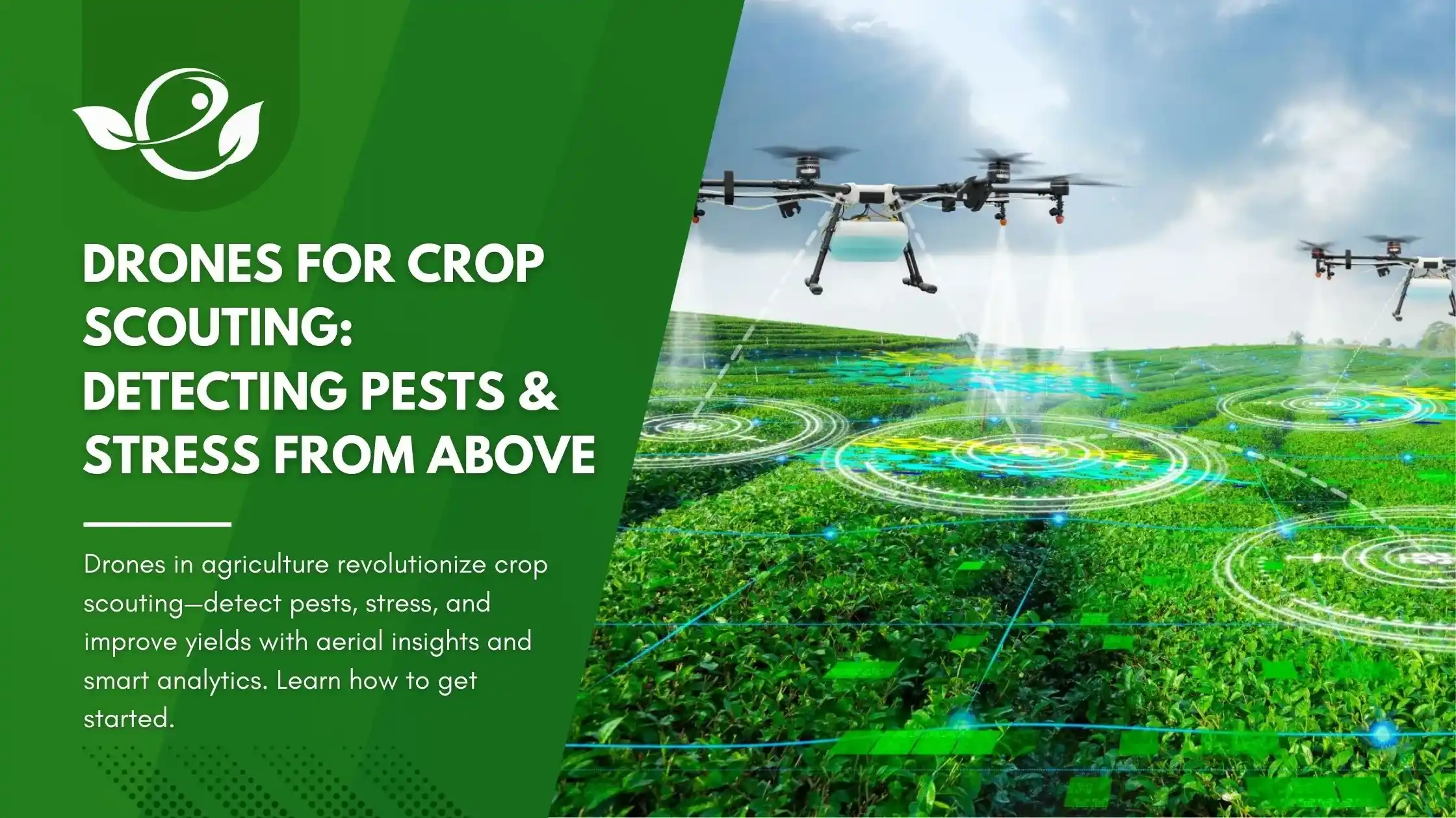
In the rapidly evolving world of agriculture, one of the most exciting developments is the use of drone technology for crop scouting. American farmers today are under pressure to produce more with less—less water, less land, and fewer inputs—all while combating the growing threats of climate stress, invasive pests, and shrinking labor availability. To meet these challenges, precision agriculture tools like drones are emerging as powerful allies.
Drones, or unmanned aerial vehicles (UAVs), have moved far beyond the hobbyist space. They’re now equipped with sophisticated sensors and imaging systems that allow farmers to monitor vast fields in minutes, detect early signs of crop stress, and spot pest infestations before they spread. This blog explores how drones are revolutionizing crop scouting and giving farmers a bird’s-eye view of their fields like never before.
The Importance of Early Detection in Crop Management
Timely crop monitoring is critical. Late detection of stress or pest outbreaks can result in significant yield losses, reduced crop quality, and increased chemical use. Traditional scouting methods—walking fields row by row—are time-consuming, labor-intensive, and often leave gaps, especially in large operations.
Why Early Detection Matters:
- Economic Impact: A minor pest infestation, if left unchecked, can escalate into a devastating outbreak.
- Targeted Response: Identifying stress early enables site-specific interventions, reducing costs and input use.
- Sustainability: Early detection reduces reliance on blanket pesticide applications, improving environmental outcomes.
Drones offer the ability to catch problems early and often, ushering in a new era of proactive crop management.
How Drones Enhance Crop Scouting
Aerial Surveillance at Scale
Drones can survey hundreds of acres in a single flight, offering unparalleled coverage in a fraction of the time compared to manual scouting. This is especially valuable during peak stress periods like droughts, heatwaves, or early pest activity.
Sensor Technology
Drones used in agriculture are typically equipped with various sensor types:
- RGB Cameras: Standard color cameras useful for spotting visible damage like discoloration, defoliation, or lodging.
- Multispectral Sensors: Capture data beyond visible light, helping detect stress indicators like chlorophyll degradation or canopy temperature changes.
- Thermal Imaging: Identifies heat signatures, revealing areas suffering from water stress or disease even before symptoms appear.

These sensors collect massive amounts of data, but it’s what happens next that truly unlocks their potential.
Data Processing & Analysis
Advanced drone platforms integrate with AI-driven analytics platforms. Here’s what that means:
- Image Stitching: Thousands of images are combined to form high-resolution field maps.
- Vegetation Indices: NDVI (Normalized Difference Vegetation Index) and others help assess plant health.
- Anomaly Detection: Algorithms flag zones showing abnormal readings, guiding scouts or agronomists to investigate further.
The result is a precise, field-wide health snapshot that’s easy to interpret and act upon.

Detecting Pests and Stress: Practical Applications
Pest Identification from Above
Pests don’t typically show themselves directly in aerial photos, but their impact does. Drones can detect:
- Patchy Damage: Irregular patterns of yellowing or wilting may indicate aphid clusters or beetle activity.
- Defoliation: Missing canopy coverage often points to chewing pests or caterpillars.
- Silk Damage in Corn: High-res imaging can highlight tassel or silk damage from pests like the corn earworm.

Repeated flights allow for monitoring the spread and progression of pest activity—crucial for Integrated Pest Management (IPM).
Stress Detection & Mapping
Drones are equally effective in spotting non-biological stress factors:
- Drought Stress: Thermal cameras reveal heat anomalies where plants are not transpiring efficiently.
- Nutrient Deficiencies: Multispectral data highlights areas with lower chlorophyll activity, potentially indicating nitrogen or potassium shortfalls.
- Fungal Infections: Many diseases manifest as subtle leaf discoloration or moisture imbalance—both detectable from above.
By identifying the exact location of problems, farmers can apply foliar sprays, irrigation, or amendments precisely where needed.
Case Studies: Success Stories from U.S. Farms
Kansas Corn Belt
A 1,200-acre corn operation in Kansas began using drone scouting in 2022. With multispectral imaging, they detected early signs of spider mite damage that were invisible from ground level. By intervening only in the affected zones, they avoided spraying the entire field, saving $18,000 in chemical costs.
California Vineyards
A vineyard in Sonoma County integrated drone scouting with their pest monitoring program. The drone imagery helped detect uneven canopy growth linked to vine mealybug infestations. Weekly flyovers tracked the effectiveness of their biological control strategy, reducing chemical use by 45%.
Florida Strawberry Growers
In Florida, drone flights every three days allowed strawberry growers to spot early signs of Botrytis (gray mold) and localized heat stress. This helped them adjust irrigation patterns and reduce yield loss during a record-setting hot season.
Choosing the Right Drone for Your Farm
Key Features to Look For:
- Flight Duration: Longer flight times (30+ mins) are essential for large farms.
- Payload Capacity: Ability to carry multispectral or thermal sensors.
- Autonomous Flight Planning: GPS-based navigation for repeatable flight paths.
- Data Integration: Compatibility with analytics software and farm management platforms.
Recommended Models:
- DJI Agras T30: Ideal for larger fields with its long range and spray capability.
- Parrot Bluegrass Fields: Compact, with multispectral sensors and easy mapping software.
- SenseFly eBee Ag: Fixed-wing drone for extensive area coverage, suited for large row crop farms.


When selecting a drone, also consider serviceability, warranty, and access to local support.
Integrating Drone Data into Farm Management Systems

Drones are only as useful as the decisions they enable. Fortunately, today’s drones can integrate with popular platforms like:
Integration Tips:
- Standardize Formats: Use .geoTIFF or shapefiles for compatibility.
- Automate Workflows: Set alerts for anomalies or low NDVI readings.
- Team Training: Ensure your agronomist or farmhand can interpret and apply the data.
The goal is a seamless pipeline from drone imagery to action in the field—be it replanting, targeted spraying, or stress mitigation.
Regulatory Considerations and Best Practices
FAA Regulations in the U.S.
To operate a drone for agricultural purposes, farmers must:
- Obtain a Part 107 Certification: Required for commercial drone operations.
- Register the Drone: All drones over 0.55 lbs must be registered with the FAA.
- Maintain Line of Sight: Pilots must see the drone at all times unless they have a waiver.
- Avoid No-Fly Zones: Check for nearby airports or airspace restrictions using apps like B4UFLY.
Best Practices:
- Pre-Flight Checks: Ensure sensors are calibrated, and batteries are fully charged.
- Data Backup: Store your imagery in the cloud or an external drive.
- Weather Monitoring: Avoid windy or wet conditions to prevent data loss and crashes.
Compliance ensures safety and protects your investment.
Future Trends in Drone-Assisted Agriculture
Autonomous Drones
The next wave of drones will feature full autonomy, where systems plan, fly, and analyze without human input. These are already being trialed in research farms.
Swarm Drones
Multiple drones coordinating to cover vast acres simultaneously will reduce scouting time even further. Expect to see this in large farms within the next few years.
AI-Powered Disease Prediction
Using historical data, weather forecasts, and drone inputs, AI tools will soon be able to predict stress events before they occur—transforming drones from reactive to predictive tools.
Carbon Mapping
As carbon farming grows, drones may be used to quantify biomass and root health, aiding carbon credit verification.
These developments promise to make drone scouting even more indispensable in sustainable and smart agriculture.
Conclusion
The sky is no longer the limit—it’s the vantage point. Drone technology has transformed crop scouting from a manual, reactive process into a high-tech, data-driven, proactive strategy. From detecting subtle signs of pest infestation to mapping nutrient stress with pinpoint accuracy, drones empower farmers with timely insights that drive smarter decisions.
Whether you manage a 50-acre vegetable plot or a 5,000-acre corn operation, integrating drones into your scouting routine can lead to better yields, lower input costs, and a more sustainable approach to farming. As the technology continues to evolve, early adopters will gain a competitive edge.
Ready to elevate your farm management with drones? Now’s the perfect time to start.
Frequently Asked Questions (FAQ)
1. How much does an agricultural drone cost in the U.S.?
Agricultural drone prices vary widely based on features and sensors. Entry-level models with basic RGB cameras can cost around $1,500–$3,000, while advanced drones with multispectral or thermal imaging, long battery life, and AI integration can exceed $10,000–$25,000.
2. Do I need internet access in the field to use a drone?
No. Most agricultural drones use offline flight planning software and GPS-based navigation. However, internet access is needed for software updates, data syncing, and uploading results to cloud platforms.
3. Can drones spray pesticides or fertilizers?
Yes. There are spray drones designed specifically for pesticide, herbicide, and foliar nutrient application. These are different from scouting drones and must comply with stricter FAA rules, including Part 137 certification for aerial application.
4. How often should I fly my drone during the growing season?
It depends on crop type and risk factors. For most crops, weekly scouting during peak growing phases is recommended. During high-risk periods (e.g., early pest outbreaks or drought), every 3–5 days may be more effective.
5. Can drones identify specific pests or diseases?
Not directly. Drones detect symptoms, such as changes in plant color, heat signature, or canopy density. While they can’t identify exact pest species, they can flag problem areas for ground validation, saving time.
6. Is drone-collected data secure and private?
Yes, most drone data is stored locally on SD cards or securely uploaded to cloud platforms with encryption. Always use reputable software and avoid public Wi-Fi when syncing sensitive data.
7. Can drone data replace ground scouting entirely?
No. Drones complement, not replace, traditional scouting. They identify hotspots quickly, but ground checks are still needed for sample collection, pest confirmation, and treatment planning.
8. What training is needed to operate an ag drone?
Commercial drone operators in the U.S. must pass the FAA Part 107 exam, which covers airspace rules, weather, and safety. Many drone suppliers also offer training programs tailored for agricultural users.
9. Are drone images good enough for insurance or legal documentation?
Yes. High-resolution drone images are often used to document crop damage for insurance claims, yield loss assessments, and legal disputes—provided they are timestamped and geotagged.
10. How long does it take to get ROI from a drone investment?
Most farmers recover costs within 1 to 2 seasons, especially when using drones to reduce input costs (chemicals, water), prevent yield loss, or optimize scouting efficiency.